In urban planning, land use and transportation are not independent variables; they are two sides of the same coin. Land use determines where people live, work, and play, which in turn dictates how they move. Conversely, the transportation infrastructure provided—whether it be highways, subways, or bike lanes—shapes how land is developed and how densely populated a city becomes. To understand modern urban challenges like traffic congestion and urban sprawl, one must look at the interplay between zoning laws, infrastructure investment, and human behavior.
The Foundation: Land Use and Zoning
Land use refers to the human use of land, representing the economic and cultural activities practiced in a specific place. To manage this, cities use zoning by-laws, which are sets of regulations that dictate what can be built on a specific piece of land. A zoning code typically consists of two main components: a map showing where specific regulations apply, and the regulations themselves, which cover aspects like land use, intensity, and impact standards.
Most cities are divided into several key functional zones:
Residential: Areas for housing.
Commercial: Retail, restaurants, and hotels.
Industrial: Manufacturing and production.
Institutional: Schools, hospitals, and government buildings.
Open Space/Parks: Recreational and natural areas.
In many North American cities, a specific phenomenon occurs known as the "Yellow Belt." In zoning maps, yellow often denotes low-density residential zones, such as detached single-family homes. In Toronto, for example, this low-density zone is 1.8 times larger than all other residential zones combined, creating massive swaths of land dedicated to a single type of housing.
This diagram illustrates different types of land use in a city, including residential, commercial, industrial, and institutional zones.
The Cost of the Automobile: Dependency and Sprawl
While transportation is not always a codified part of zoning, it consumes a massive amount of physical space. In automobile-dependent cities, roads and parking can account for 35% to 50% of the total land-use footprint.
Car Dependency and Induced Demand
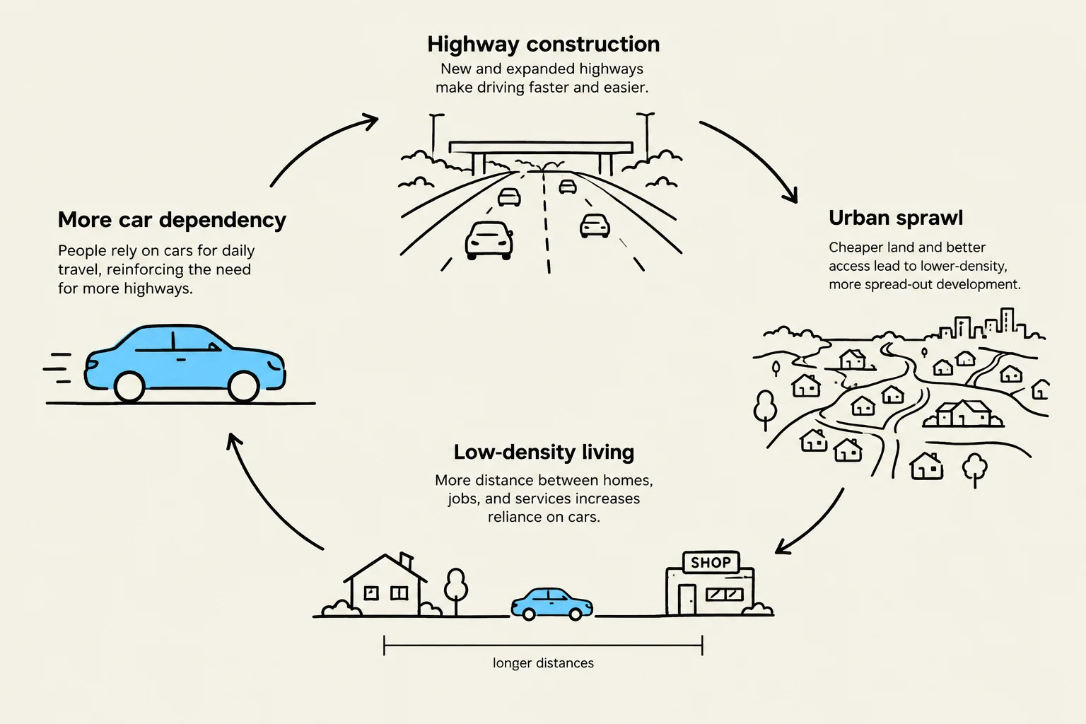
When land use is characterized by low-density development (like the "Yellow Belt"), it naturally encourages car dependency. This creates a self-reinforcing cycle: as more roads are built to accommodate cars, the city spreads out further, a process known as urban sprawl.
A critical concept in this cycle is induced demand. This principle suggests that increasing road capacity (e.g., building more highway lanes) does not actually solve congestion in the long term; instead, it encourages more people to drive and encourages further low-density development, which eventually leads back to congestion.
The Hidden Land Use: Surface Parking
One of the most significant "invisible" land uses is the surface parking lot. In North America, these lots represent 5% to 7% of urban land. Interestingly, within a parking lot, only about 40% of the surface is actually used for parking vehicles; the remaining 60% is dedicated to circulation and access lanes.
Beyond the space they occupy, parking lots impact urban health. They score very low on walkability audits—often performing worse than major roads—because they lack shade, lighting, and pedestrian-friendly features.
This diagram illustrates the cyclical relationship between highway construction, urban sprawl, low-density living, and increased car dependency.
Exam Tip: If asked about the relationship between transport and land use, remember that it is a "two-way street." Land use (zoning) dictates transport modes, and transport infrastructure (highways) shapes land use (sprawl).
Reversing the Cycle: Smart Growth and TOD
To combat sprawl and car dependency, urban planners utilize strategies designed to create more sustainable, compact, and efficient cities.
Smart Growth
The American Planning Association defines Smart Growth as a pattern of compact, transit-accessible, pedestrian-oriented, and mixed-use development. The goal is to move away from single-use zoning (where you must drive to get from a house to a shop) and toward patterns that allow for more diverse travel options.
Transit-Oriented Development (TOD)
A primary tool for implementing Smart Growth is Transit-Oriented Development (TOD). This involves maximizing residential, business, and leisure space within walking distance of public transport.
Effective TOD requires mixed-use development, where different types of zones (residential and commercial) are integrated into the same area. This ensures that once a person reaches a transit station, they have destinations to go to without needing a car.
Real-World Challenges: The Case of GO Transit
Even well-intentioned transit systems face land-use hurdles. For instance, many GO Transit stations are designed with massive, free parking lots (e.g., Appleby GO station). This can actually discourage a "modal shift" (moving from cars to trains) because:
It is expensive to provide free parking, which can limit passenger numbers to only those who can fit in the lot.
It creates an unfairness where bus users pay fares while car users park for free.
It discourages walking if the station is surrounded by car-centric infrastructure.
Successful examples, like West Harbour, show the potential of TOD by being highly walkable and having areas re-zoned so people can actually live near the station.
Study Summary Table: Development Patterns
Feature
Low-Density / Sprawl
Smart Growth / TOD
Primary Mode
Private Automobile
Walking, Cycling, Transit
Zoning Type
Single-use (Separated)
Mixed-use (Integrated)
Land Efficiency
Low (High parking/road %)
High (Compact footprint)
Walkability
Low
High
By integrating land use and transport through smarter zoning and denser, mixed-use development, cities can break the cycle of car dependency and create more livable, sustainable environments.
Keep reading for free.
Create an account to finish this reading and make it part of your study routine.