The Physics of Clouds: Temperature's Role in Formation and Icing Hazards
Explores how temperature influences cloud formation, water droplet dynamics, the freezing process, and the resulting icing hazards for aircraft. Covers super-cooled water, ice crystal formation, and different types of aircraft icing.
Cloud formation is not merely a matter of moisture meeting air; it is a complex thermodynamic process governed heavily by temperature. Temperature dictates how much water the air can hold, the physical state of the water within the cloud, and the specific hazards presented to aircraft flying through these environments. Understanding these relationships is critical for flight safety, particularly when transitioning between different thermal layers.
Water Holding Capacity and the Cloud Base
The relationship between temperature and moisture begins with the concept of water holding capacity. Warm air has a significantly higher capacity to hold water vapor than cold air. This means that as air warms, it can support a greater amount of evaporated moisture before reaching saturation.
When air cools, its capacity to hold vapor decreases, leading to condensation. The temperature at which this process begins often defines the cloud base. A warmer cloud base allows for more water to be condensed out of the air mass, which can lead to a higher liquid water content within the cloud.
This illustration demonstrates how warmer air can hold more water vapor than colder air. It shows three scenarios: cold air at 0°C with a capacity of approximately 4 g/m³, mild air at 15°C with a capacity of approximately 12 g/m³, and warm air at 30°C with a capacity of approximately 30 g/m³. A graph further illustrates the relationship between temperature and water vapor capacity, showing an increasing trend.
Droplet Dynamics and the Role of Vertical Currents
Once condensation occurs, the temperature determines the size and number of the resulting water droplets. This is a vital factor because the "Liquid Water Content" (LWC)—a measure of the amount of liquid water in a given volume of cloud—is dependent on both the size and the concentration of these droplets.
In many cloud types, such as layer (stratus) clouds, the droplets are small and the vertical movement is limited. However, in convective clouds like Cumulus (CU) or Cumulonimbus (CB), strong vertical currents and updrafts play a decisive role. These powerful updrafts can carry large water droplets upward so rapidly that they are prevented from falling out of the cloud, even as they reach much colder, higher altitudes.
Exam Tip: Remember that the strongest vertical currents and the largest water droplets are typically found in convective clouds or clouds formed by abrupt orographic lift.
The Freezing Process: Super-cooled Water and Ice Crystals
As temperature drops, the physical state of the water changes. A critical phenomenon in aviation is the existence of super-cooled water droplets. These are liquid water droplets that exist at temperatures below 0∘C but have not yet frozen. They remain liquid until they encounter a surface—such as an aircraft airframe—that is below freezing, at which point they freeze instantly upon impact.
The temperature also dictates the transition from liquid to solid through two main processes:
Spontaneous Freezing: Larger droplets begin to freeze spontaneously into ice crystals at approximately −10∘C. As droplets get smaller, even colder temperatures are required to induce freezing. By −40∘C, virtually all droplets in a cloud will have frozen.
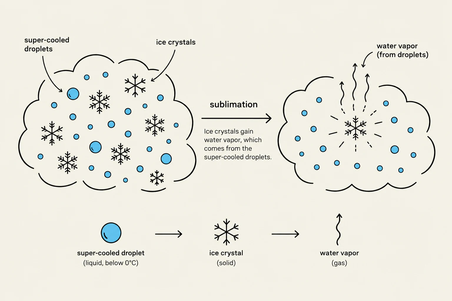
Sublimation: In environments where water droplets and ice crystals coexist, a process called sublimation occurs. Water droplets evaporate, and the resulting vapor deposits directly onto the ice crystals. This causes the ice crystals to grow rapidly and settle downward, which can deplete the liquid water content of the cloud and cause rapid fluctuations in droplet numbers.
This diagram illustrates the process of sublimation, where ice crystals grow by gaining water vapor from super-cooled droplets.
Icing Hazards and Aircraft Impact
The interaction between temperature, droplet size, and aircraft movement creates specific icing hazards. The severity of icing is often highest near the cloud tops of convective clouds, provided the temperature is not extremely cold (below −15∘C), because the ascending air carries the maximum liquid water content toward the top.
The type of ice that forms on an aircraft depends on the freezing rate:
Clear Ice: Formed by the slow freezing of large droplets. This ice is transparent, heavy, and adheres strongly to surfaces, making it the most hazardous type.
Rime Ice: Formed by the almost instantaneous freezing of small super-cooled droplets. It appears milky, opaque, and brittle.
Mixed Ice: Occurs when large and small droplets coexist, resulting in an irregular, whitish appearance.
Icing Type
Droplet Size
Freezing Rate
Appearance
Clear
Large
Slow
Transparent/Glass-like
Rime
Small
Rapid
Milky/Opaque
Safety Note: If you encounter icing in stratus clouds, immediately activate ice protection systems and consider a vertical change of approximately 3,000 feet to exit the icing environment.
Special Meteorological Conditions
Temperature variations at frontal boundaries can lead to freezing rain. This occurs when snow falls from above-freezing temperatures, melts into rain, and then falls into a layer of below-freezing air. This creates super-cooled rain that produces severe clear ice upon impact. Similarly, freezing drizzle occurs when super-cooled droplets in stratus clouds coalesce and fall; because these droplets are larger than standard cloud droplets, they often cause severe clear icing near the cloud base.
Finally, in clear air, hoar frost can form through sublimation, where water vapor changes directly into ice crystals on the aircraft surface. This is particularly dangerous because even a light coating can significantly increase the stall speed of the aircraft.
Keep reading for free.
Create an account to finish this reading and make it part of your study routine.