Cloud Formation, Classification, and Lifting Mechanisms
This guide explains the fundamental processes of cloud formation, including the four primary lifting mechanisms: surface heating, converging winds, orographic lifting, and fronts. It details cloud nomenclature and classification by altitude (high, middle, low) and vertical growth, covering genera like Cirrus, Cumulus,
To the casual observer, the sky is a shifting canvas of white, gray, and blue. However, to a meteorologist, these shapes are precise indicators of atmospheric stability, moisture content, and upcoming weather patterns. Clouds are not merely random collections of water droplets; they are organized structures formed by specific physical processes and classified by their appearance and altitude. By understanding the nomenclature of cloud genera and the mechanisms that force air to rise, we can decode the complex language of the atmosphere.
The Engine of Cloud Formation: Lifting Mechanisms
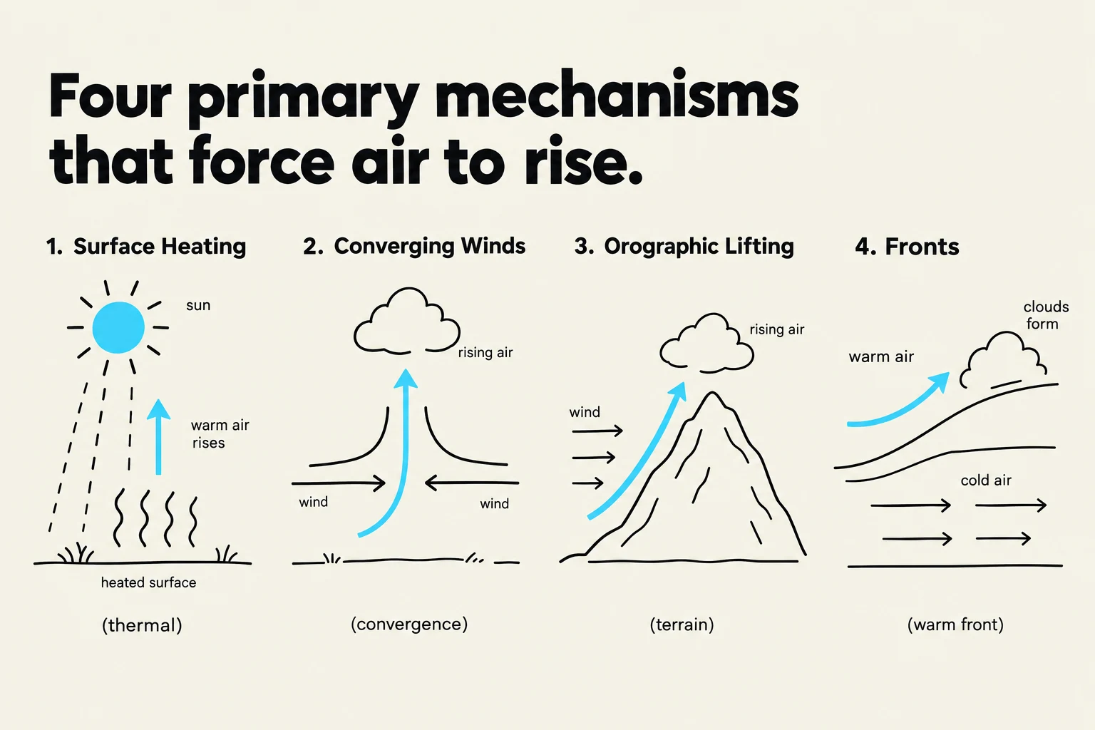
Diagram illustrating four primary mechanisms that cause air to rise: surface heating, converging winds, orographic lifting, and fronts.
Clouds form when air rises and cools. As an air parcel ascends, it encounters lower atmospheric pressure, causing it to expand and cool. If the air cools to its dew point, water vapor condenses onto microscopic particles known as cloud condensation nuclei—such as sea salt or sulfate particles—to form visible droplets.
But what forces the air to rise in the first place? There are four primary lifting mechanisms that drive this process:
Surface Heating: On sunny days, the sun warms the Earth's surface, which in turn warms the air directly above it. This warm air becomes less dense and rises in columns known as thermals.
Converging Winds: When air masses from different directions meet, they have nowhere to go but up. This convergence forces the air to ascend, often creating boundaries like sea-breeze fronts.
Terrain (Orographic Lifting): When wind encounters a physical barrier like a mountain range, the air is mechanically forced upward along the slope.
Fronts: In a frontal system, a warm air mass meets a colder, denser air mass. Because the warm air is less dense, it is forced to slide up and over the colder air.
Exam Tip: Remember that a cloud does not form simply because air rises; the air must rise far enough to reach saturation through cooling.
Decoding Cloud Nomenclature
Cloud names are not arbitrary; they are constructed using specific prefixes and suffixes that describe the cloud's physical form and its altitude:
Prefix/Suffix
Meaning
Cumulo-
Heaped or cellular form
Strato-
Layered or sheet-like form
Cirro-
High-level clouds
Alto-
Middle-level clouds
Nimbo- / -nimbus
Precipitation-bearing clouds
By combining these elements, meteorologists can precisely describe a cloud's character. For example, altocumulus tells you the cloud is a "heaped" (cumulo) "middle-level" (alto) cloud.
Classification by Altitude
This diagram illustrates the classification of clouds based on their altitude in the troposphere, categorizing them into high, middle, and low levels, and depicting common cloud types within each category such as Cirrus, Cirrostratus, Altostratus, Altocumulus, Stratus, and Stratocumulus.
Clouds are organized into three primary altitude families based on their cloud-base height.
High Clouds (Ice Crystal Clouds)
Located at the highest altitudes, these clouds are composed primarily of ice crystals rather than liquid droplets.
Cirrus: Wispy, fibrous streaks often caused by wind shear stretching falling ice crystals.
Cirrostratus: Thin, high-level sheets that can cover much of the sky and often produce a halo effect around the sun or moon.
Cirrocumulus: Small, high-altitude ripples or grains that show very little shading.
Middle Clouds
These clouds occupy the intermediate levels of the troposphere.
Altostratus: Broad, gray or bluish sheets. They are often thick enough that the sun appears only dimly through them.
Altocumulus: Patches, rolls, or rounded elements. These appear larger and show more distinct shading than the higher cirrocumulus clouds.
Low Clouds
These clouds form at lower altitudes and are often associated with overcast conditions.
Stratus: A uniform, low-level layer that often creates a complete overcast sky and may produce light drizzle.
Stratocumulus: Low layers characterized by rounded elements or rolls, providing more texture than a smooth stratus layer.
Nimbostratus: Deep, extensive, and dark layers that bring steady, widespread precipitation such as rain or snow.
Vertical Growth and Convection
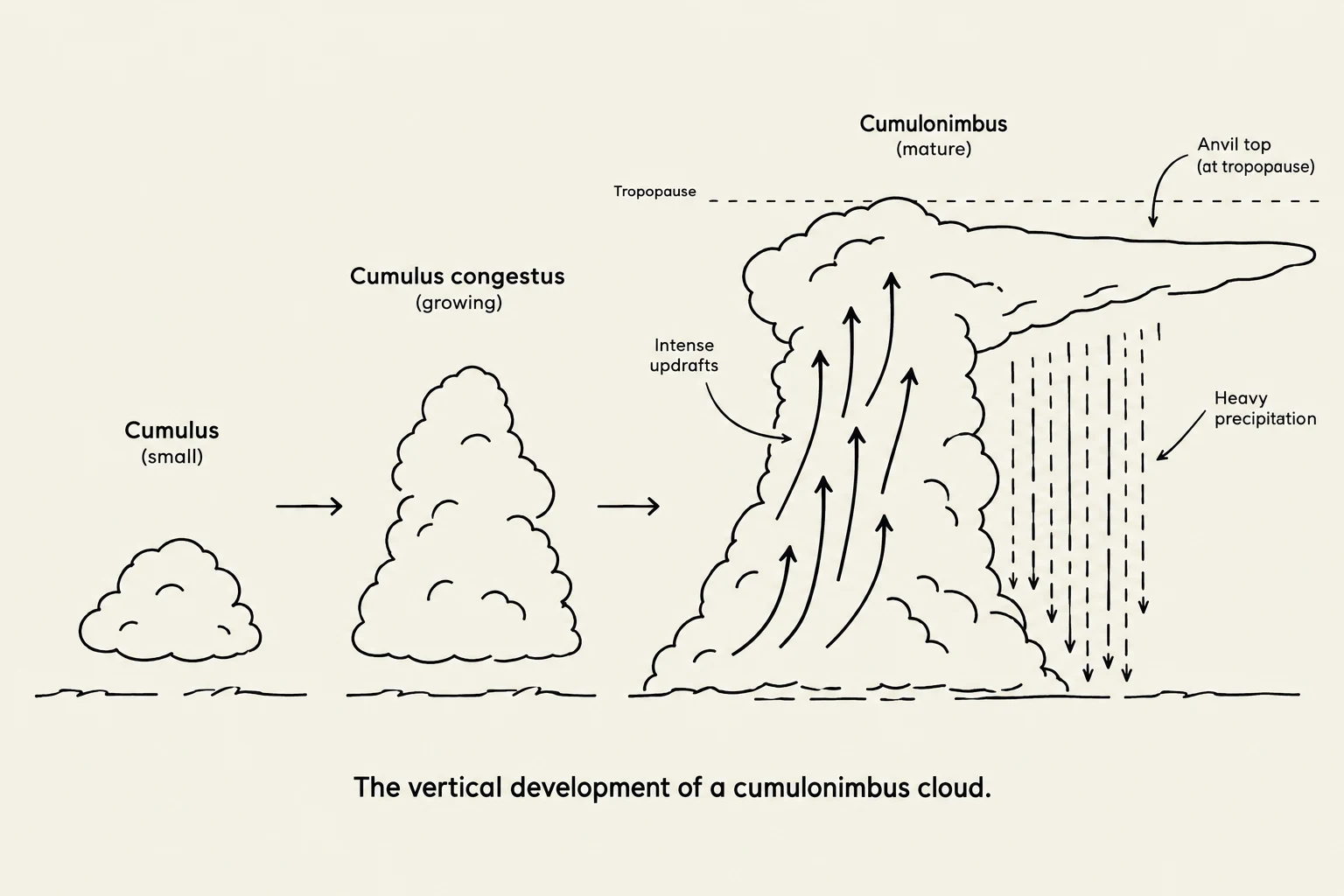
The vertical development of a cumulonimbus cloud.
While altitude families categorize clouds by their base, some clouds exhibit significant vertical growth, spanning multiple altitude layers. This is driven by deep convection.
Cumulus clouds are the classic "puffy" clouds with distinct, often flat bases, typically forming above rising thermals. When these clouds undergo intense upward development, they become cumulus congestus (towering cumulus), characterized by sharp, cauliflower-like edges.
The most powerful of these is the cumulonimbus. This is a deep convective cloud associated with thunderstorms and heavy showers. A hallmark of a mature cumulonimbus is the anvil top, where the cloud reaches the top of the troposphere and spreads out horizontally due to high-altitude winds.
Observation Note: While some clouds are categorized by their base, the cloud-top height is equally important for understanding the intensity of a storm and the potential for severe weather.
Summary Table of Cloud Genera
To help visualize the relationship between appearance and level, refer to the following summary:
Family
Genera
High
Cirrus, Cirrostratus, Cirrocumulus
Middle
Altostratus, Altocumulus
Low
Stratus, Stratocumulus
Deep/Vertical
Nimbostratus, Cumulus, Cumulonimbus
Keep reading for free.
Create an account to finish this reading and make it part of your study routine.